- Created: March 13, 2019 9:16 am
- Updated: March 13, 2019 9:30 am
- Distance 17.05 km
- Time 6 h 45 min
- Speed 3.0 km/h
- Min Altitude 274 m
- Peak 449 m
- Climb 716 m
- Descent 719 m
- Distance Instructions
- Travel Mode:
- Walking
- Bicycling
- Driving
- Straight-line
1. Khirbet Qarqash
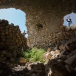
Drawings of the sun and the moon are visible at the main entrance of Khirbet Qarqash (it is also known as the Sun and the Moon hamlet) which is located to the northeast of Bruqin village to the west of Salfit. It has two parts: the upper and the lower. The upper part includes a residential area, caves, water wells, quarries, ponds, olive and grape mills and a mosque, while the lower part contains tombs and cemeteries.
Khirbet Qarqash contains forts, ponds and paths carved into rocks in addition to artistic sculptures engraved on columns and unexplored underground traces. The level of water in its ponds reaches between 6 to 7 meters.
It also has a cave that leads to small crypts that were used as tombs for kings and princes in ancient times. Inside each crypt there is another crypt or a small pond where food was presented to the dead based on the belief that there is another life after death.
2. Khirbet Jalal ad-Dein
Khirbet Jalal ad-Dein or Khirbet al-Matwi is an ancient village located on the top of a mountain slope about 455 meters above sea level, between the city of Salfit and the town of Bruqin in the western part of the province. Its history dates back almost to the early Ottoman period, and contains organized distrusted houses and a tomb that people believe it belongs to the noble Jalal ad-Dein.


